The gap between digital model theory and real-world conditions is a major barrier to industrial performance. Most infrastructures suffer from outdated data: equipment is difficult to locate, inventories are incomplete, and maintenance operations take too long. One solution to ensure digital continuity is digital twins.
To address these challenges, and in alignment with ISO 30173:2023, b<>com, in co-development with its ecosystem of industrial stakeholders, is conducting ambitious research at the intersection of digital twins and artificial intelligence.
Objective: to turn raw 3D data into a strategic decision-making lever. By providing an accurate, up-to-date, and actionable representation of the physical environment, we enable dynamic management of infrastructure and assets, which is essential to reducing costs and the complexity of maintenance operations.
Spatial AI in the Service of Digital Twins
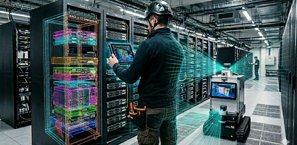
LiDAR scanning and photogrammetry capture physical environments as 3D point clouds. While these representations are becoming increasingly accurate, they face a major limitation: machines cannot understand them. A raw point cloud does not allow for object identification, equipment querying, or the feeding of a Building Information Modeling (BIM) model. Without semantics, 3D data remains operationally unusable.
It is precisely these limitations that our teams in AI, computer vision, and image processing are addressing. Thanks to Spatial AI and the inference capabilities of semantic classification models, machines can now understand and interpret 3D reconstructions of real-world environments by recognising, segmenting, and locating equipment and objects
For example, AI-based semantic segmentation groups 3D points into recognised objects, enabling automatic detection of discrepancies between reality and the digital twin and recommending updates to be made to the BIM manager within a reverse engineering framework.
3D point clouds are an extraordinary raw material that is still too often underexploited. By applying spatial AI models combined with computer vision, we are reaching a decisive milestone: we are moving from a simple visual representation to an intelligent model capable of understanding an environment, identifying its components, and recommending actions. It is this qualitative leap that gives the digital twin its full operational value.
Practical Applications of Spatial AI in Digital Twins
Simulating the installation of new equipment using an up-to-date digital twin
3D digital twins (also known as virtual twins), continuously updated, enable engineering teams to remotely validate the installation of new equipment and to simulate its impact on a model that accurately reflects reality rather than an outdated one.
Monitoring a production site remotely through real-time updates of a 3D digital twin
The fusion of static vision sensors (monitoring cameras) and mobile systems (SLAM algorithms, robots, connected glasses) enables real-time updates of the 3D digital twin and allows a production tool to be operated remotely based on its actual state. However, the spatial and temporal synchronisation of these sensors (LiDAR and cameras) remains a major challenge for ensuring the accuracy of these updates.
See through infrastructure to accelerate field interventions
Augmented reality, combined with digital twins and computer vision, enables technicians to quickly visualise and locate equipment and underground networks that require intervention, in other words, to ‘see through objects’ thanks to precise 3D localisation provided by augmented reality systems in both indoor and outdoor environments.
Projecting environmental impact before even starting a construction site
The use case is shifting toward environmental projection: visualising a future installation in augmented reality within its real-world context. This requires effective management of occlusions between real and virtual elements, and even the removal of existing elements, to ensure a realistic rendering.
To learn more
The value of resource sharing between industrial requirements and business expertise
Each industrial member of b<>com contributes specific domain expertise that complements the technical expertise of b<>com teams. This complementarity makes it possible to address the full range of challenges related to the digitisation of physical infrastructure, while maximising the operational impact of the solutions developed.
Key Benefits for Industry:
- Reduction of maintenance costs and intervention times for predictive maintenance through enhanced equipment localisation on site;
- Interpretation of 3D scans to give them meaning and enable machines to understand the real-world environment;
- Automatic, real-time updating of the as-built state of 3D digital twins, made usable from raw point clouds through spatial AI;
- Anticipation of the environmental impact of new installations through mixed reality projection;
- Improved field augmented reality perception through mediated reality technologies.
To learn more about collaboration opportunities with b<>com in these areas or to join its innovation ecosystem, feel free to contact our team.